In contrast to places like Pease Bay (which is still very beautiful and you should still visit it), there are places like Cove. At Cove, there's no river to cut down through the sandstone. Instead, part of the cliff has slumped down, leaving a half-moon bay, bounded on one side by the continuing line of cliffs, while on the other a line of harder sandstone extends into the sea, parallel with the cliffs. The whole bay has been enclosed by walls, creating a very secluded harbour:
Cove is not the sort of place one could possibly find caravans.
We parked in a gravelly area between two houses. We'd brought a picnic, and since it was lunchtime, we decided to munch it next to the car, rather than carting it about. We got out the rolls, sliced cold meat, salad, and boiled eggs, and carefully balanced them on the edge of a yacht trailer nearby. To the weather, this was the equivalent of a red flag to a bull. The puny humans should know better than to picnic in the open air in the summertime! While we were spreading our sandwiches, a large and ominous looking cloud appeared in the previously blue and cloudless sky. The sun grew cold, and the hills underneath the cloud disappeared in a fog of rain.
The weather hadn't bet on there being two sailors in the family, both of whom had (necessarily) developed a fair ability to work out how far away rain was, and how long it would be until it hit. The sandwiches were spread and filled, eggs were shelled, and the picnic stuff was packed into the boot of the car. We then leapt into the car with our plastic plates of sandwiches and eggs, and a poke of salt, just as the first drops hit the windows.
The shower was short and sharp, and ceased as soon as the last morsel had been devoured. As if a switch had been flicked, the sun came out, the clouds disappeared over the horizon, and it was as though the shower had never been. After all, there was no more picnic.
The way down to Cove harbour is via a track down the side of the cliffs, accessed by a set of stairs. This is the view from the top of the cliffs near where the track started. Looking North:

Looking north from further round. You can see the layering in the cliff, and how unstable the sandstone is:

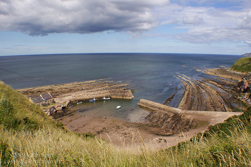
And looking towards Cove harbour. The track can be seen running down the side of the cliff:

From further down the track:

The coast looks unforgiving, there's no evidence to show that you're very near what was once a pretty hospitable harbour, with a good fish trade. Here's a photo of the harbour which fishing boats in the 1920s:

The rocks just off the cliffs continue both north to Dunbar, and South to Berwick, creating a formidable coastline.
On the 14th of October, 1881, tragedy struck right along the East coast. Shortly after the fleets had left to fish, "the sky took on an inky blackness..., and within a few minutes, a hurricane raged". The skippers of the open fishing boats had to choose: run out to sea before the wind, or make for shore through the rapidly growing waves. Most of the men chose to run for shelter - after all, they were not far off shore.
All along the coast, the women, children, and old men gathered at the harbours, watching their men who struggled against waves which threatened to dash their boats on the rocks, and against the wind which tore their sails.

The wind was too fierce, and swell too great; the boats were dashed to pieces on the rocks along the shore, or foundered out at sea. There was nothing those on shore could do, but watch, and wait.

Of the five boats and 21 men who put to sea from Cove that day, only one boat - ten men - returned. All along the coast the story was the same. The only ones to survive were those who had run before the storm. Altogether, 189 men were lost, leaving behind 93 widows and 267 children. Eyemouth, -a town just south of Cove - lost 129 men and one third of the fishing fleet. Even Musselburgh and Newhaven (Edinburgh) lost men; 7 in Musselburgh and 15 in Newhaven.
It was the communities on the Berwickshire coast which were proportionally hardest hit though; in a community of only 3 or 4 families, all of which survived on the fishing trade, the loss of more than half the working men seriously jeapordised those left behind. It was - and still is - the East Coast's worst maritime disaster.
The memorial sculpture was designed by Jill Watson, a resident of Cove, who was commissioned to make scultures for Eyemouth, Cove, and St Abbs, commemorating the disaster.
Sobered, and shivering slightly despite the hot sun, we continued down the cliff to the harbour. As the track takes you round the end of the headland, this is the view that opens up:

A little closer, and the track splits...

At the junction, this is what you see on your right:

Amazingly, we didn't head straight for the tunnel, despite both my brother and I having a familial affinity for caves, tunnels, cellars and the like.
The tunnel runs through a promontory which forms one side of the bay. Beyond the cliff, this is the first view of Cove beach that you get:

People used to live in the cottages, but now they're half derelict, though there are signs that they're being renovated. They are - or were - used for fishing things:

Most of the fishing from Cove nowadays is for lobster and crab:

Looking out to sea:

I had a brief melancholy moment, thinking how calm and blue the sea was, in comparison to the day of the storm.
There are two working boats in Cove today:

Look at the cliffs stretching out down the coast!
This is the other side of the harbour, complete with

That large grey outcrop (not the one with a hole in it) behind the harbour wall is known as Cathedral Rock, because of the shape.
Standing outside the cottages, looking back the way we'd come. This is the headland the tunnel runs through; it's the only way to get to the beach at high tide, or without scrambling about on rocks. You can see why they carved it out:

Much of the northern (main) wall of the harbour is formed by a natural rock outcrop, built up, or with stairs cut into it:


The cottages themselves are very photogenic:


Look at the weathering on the door! It would be amazing to be snuggled away inside here during a winter storm.
I liked the look of this vessel:

She was moored near the steps cut into the harbour wall, above, so I scrambled down and took some pictures.

This is what's on the other side of the steps. It really shows how much of the harbour isn't man-made:

Looking at the harbour mouth from the steps:

On the way back up (they're pretty steep!). I think this is one of my favourites:

There were originally four cottages on the harbour wall, though only two are now standing; this is all that remains of the upper cottage:

These cellar doors used to open into the cellar of the last cottage. They weren't locked, so my father and I peered in (like I said, family fascination with caves, tunnels, cellars...). It was supported by scaffolding, was really wet, and was full of all sorts of fishing and boating paraphernalia, from chunks of fiberglass from damaged boats, to nets dating from the turn of the century. It didn't look particularly safe, and we were aware that we were peering into someone else's property, so we left...

Next to the cottage there are these steps cut into the outer wall:

I scrambled up and had a look out to sea, of course.
The harbour wall on this side has always been the "working" side of the harbour. Nowadays most of the boats are moored by ropes, but there are still chains which go over the edge and down to trot lines below the sand:

They're very photogenic:

We then headed right the way out to the very end of the harbour wall. This is looking back at the cottages, with some very pleasingly dramatic clouds:

Behind the working fishing boats, there was quite a pungent smell. They deal with the catch once they're moored, throwing all the waste over the side, so through the water we could see bits of crab and fish heads. It was still very photogenic:

At the end, the harbour wall is about 12 foot high, a testament to the sort of storms they get here. On the inside, it's composed of about 7 or 8 big steps, which are good for sitting on. I climbed up to the top and looked over. This is the channel into the harbour:

The rocks right next to the channel; you'd have to steer very carefully coming in, there's not much room for error:

Looking across at the houses in the bay, and the other half of the harbour wall:

Looking across the harbour at the tunnel headland. You can see the end of the tunnel, protected from rock falls by a tin roof. The headland's riddled with caves too - we didn't get the chance to explore that one that is tantalisingly almost - but not quite - blocked up:

We saw these cut into the cliffs beyond the other half of the harbour wall:

It took a long time for a proper harbour to be built at Cove, due to the terrain. In the meantime, boats did still fish here, and dock here. We think probably the steps and foot holds were cut into the rock so that at high tide the catch could be brought back to the beach. The steps stop at the tide mark, and there's a channel between the rocks up which the boats could have been brought.
We headed back round to explore the tunnel and the rest of the bay. On the way back, I noticed these oilskins hanging on a hook:

I really liked this touch, it was so human! The fishermen weren't around, which made it even nicer. I like the idea that once the catch has been landed, they hop off the boats, hang their fishy oilskins up, and then head home.
This entry has got quite long enough, so I'll stop there.
If you're interested in the 1881 disaster, here are some links for more pictures and further reading:
Wikipedia entry
World of Boats writeup. This gives a good idea of the scale of the disaster.
Resources for Learning - some photos here.
More about the effect on the coast
A good article with lots of information
A news article
A picture and a short account
BBC News article about a ceremony to mark the loss of life. I think this demonstrates how deeply Eyemouth and the Berwickshire coastal communities were affected; 100 years later the loss is still very real to people.